تحميل الارتفاعات الرقمية للسطح DSM مجانا

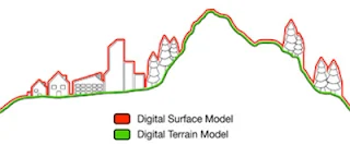
الارتفاعات الرقمية للسطح تأخذ بعين الاعتبار ارتفاع المباني والاشجار.. بينما الارتفاعات الرقمية للأراضي DTM تنبني على النموذج الرقمي للأراضي بحيث يتم الاستغناء عن علو الأشجار والمباني.. بينما DHM هي الفارق بين DSM و DTM.. يمكنكم التسجيل في الموقع من هنا التسجيل في موقع eorc.jaxa.jp تحميل الارتفاعات الرقمية للسطح DSM
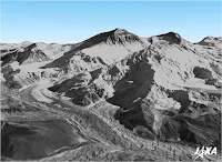
يمكنكم تحميل الارتفاعات الرقمية للسطح DSM) Digital Surface Model) بدرجة وضوح 30متر  الخاصة بمشروع ALOS اليباني..
 ALOS Global Digital Surface Model "ALOS World 3D - 30m" (AW3D30) 
 ALOS Global Digital Surface Model "ALOS World 3D - 30m" (AW3D30)
 ALOS Global Digital Surface Model "ALOS World 3D - 30m" (AW3D30) .. هذه الارتفاعات الرقمية للسطح متوفرة مجانا للتحميل فقط يجب التسجيل بالموقع.. ونشير إلى أن الارتفاعات الرقمية للسطح تأخذ بعين الاعتبار ارتفاع المباني والاشجار.. بينما الارتفاعات الرقمية للأراضي DTM تنبني على النموذج الرقمي للأراضي بحيث يتم الاستغناء عن علو الأشجار والمباني.. بينما DHM هو الفارق بين DSM  و DTM..

يمكنكم التسجيل في الموقع من هنا 

إذا واجهتكم أي مشكلة في التسجيل أو التحميل يمكنكم اتباع الخطوات الموضحة في الفيديو 


إعداد وتقديم جمال شعوان Jamal Chaaouan


Open All Collapse All Refresh Feeds
RSS Feeds & Updates
Geospatial Tools

GIS & Remote Sensing

Workflows and tutorials on spatial data and imagery analysis.

gis.geojamal.com

Remote Sensing Indices

Explore NDVI, SAVI, NDWI and many spectral indicators.

rs.geojamal.com

GeoAI & ML

Machine learning tools and spatial intelligence applications.

geoai.geojamal.com
Mapping & Visualization

Map Resources

Shapefiles, basemaps and vector tiles for GIS projects.

maps.geojamal.com

Earth Tools & Maps

Explore satellite viewers, terrain tools and visual apps.

earth.geojamal.com

Coordinate Tools

View, transform and clean coordinates on a live map.

coordinates.geojamal.com
AI & Smart Processing

GeoAI & ML

AI tools for automated analysis of Earth data.

geoai.geojamal.com

GEE Scripts & Apps

Google Earth Engine apps and tutorials.

gee.geojamal.com
Coordinate & File Converters

Geo Format Converter

Convert CSV, KML, GPX, GeoJSON, Excel, and more.

convert.geojamal.com

Coordinate Tools

Live projection and geocoding tools.

coordinates.geojamal.com
Learning Platforms

TV: English Tutorials

Video content for GEE, GIS, remote sensing in English.

tv.geojamal.com

TV: Arabic Tutorials

Arabic video lessons on mapping and geospatial analysis.

ar.tv.geojamal.com

How-To Guides

Written tutorials and step-by-step guides.

howto.geojamal.com

GeoJamal بالعربية

الموقع الرسمي للمحتوى العربي في نظم المعلومات الجغرافية، الاستشعار عن بعد، والخرائط الذكية.

ar.geojamal.com
Downloads & Resources

Downloads Center

Free GIS tools, satellite data, software and add-ons.

downloads.geojamal.com

SASPlanet Center

Offline satellite downloading and map exploration tools.

sasplanet.geojamal.com
GPS & Field Tools

GPS Utilities

Geotagged photos, live location, export to KML or GPX.

gps.geojamal.com

Coordinate Tools

Field-ready conversion and projection mapping support.

coordinates.geojamal.com
Multilingual Access

GeoJamal بالعربية

الموقع الرسمي للمحتوى العربي في نظم المعلومات الجغرافية، الاستشعار عن بعد، الذكاء الاصطناعي الجغرافي، وتحليل الخرائط.

ar.geojamal.com
Name

3D,13,ArcGIS,24,Archydro,3,Aster,2,biogeographie,16,Books,31,Courses online,29,Data,6,DEM,8,Download,3,Free,9,Geology,4,GIS,37,Google Earth,14,Google Earth Engine,1,Google Earth pro,14,Google Maps,6,GPS,2,Landsat,20,Mapinfo,2,maps,22,move,30,Open source,15,Projection,4,QGIS,7,Remote Sensing,47,SASplanet,11,Satellite,8,Sentinel,2,SPSS,13,Statistic,17,Update,8,Windows,4,أخبار,3,اختبارات,7,الإحداثيات,4,الإحصاء,16,الارتفاعات الرقمية للأراضي,6,الاستشعار عن بعد,48,البيئة,5,البيوجغرافيا,19,التعرية,10,الجغرافيا,55,الجغرافية الطبيعية,40,الجهات,1,الجيومورفلوجيا,10,المناخ,15,برامج,33,تقارير,1,جغرافية الصحة,1,جيولوجيا,4,خرائط,24,دروس,42,دورات تكوينية,1,كتب,32,مشاكل وحلول,26,ندوات,1,نظم المعلومات الجغرافية,53,
ltr
item
GeoJamal – Digital Geography & GeoAI: تحميل الارتفاعات الرقمية للسطح DSM مجانا
تحميل الارتفاعات الرقمية للسطح DSM مجانا
الارتفاعات الرقمية للسطح تأخذ بعين الاعتبار ارتفاع المباني والاشجار.. بينما الارتفاعات الرقمية للأراضي DTM تنبني على النموذج الرقمي للأراضي بحيث يتم الاستغناء عن علو الأشجار والمباني.. بينما DHM هي الفارق بين DSM و DTM.. يمكنكم التسجيل في الموقع من هنا التسجيل في موقع eorc.jaxa.jp تحميل الارتفاعات الرقمية للسطح DSM
https://blogger.googleusercontent.com/img/b/R29vZ2xl/AVvXsEikQITzPcYNGnHyp-bCvGId-xIRaIx6BH7dAmSvE158GqLnU6fx7jI2myczYmHZE5Ay0-7_nXGr3EsUyq3S7fAPlcEZR_flUqAaNHUbvFK-ZCohgH4S5uqp7P0vGHsc6WRRG9zF51Csg8go/s320/dem-overview.jpg
https://blogger.googleusercontent.com/img/b/R29vZ2xl/AVvXsEikQITzPcYNGnHyp-bCvGId-xIRaIx6BH7dAmSvE158GqLnU6fx7jI2myczYmHZE5Ay0-7_nXGr3EsUyq3S7fAPlcEZR_flUqAaNHUbvFK-ZCohgH4S5uqp7P0vGHsc6WRRG9zF51Csg8go/s72-c/dem-overview.jpg
GeoJamal – Digital Geography & GeoAI
https://www.geojamal.com/2018/01/downloadfreedsmdem.html
https://www.geojamal.com/
https://www.geojamal.com/2018/01/downloadfreedsmdem.html
true
1335553610185428310
UTF-8
إظهار كافة المواضيع لم يتم العثور على أي موضوع إظهار الكل المزيد.. رد إلغاء الرد حذف بواسطة Home صفحة موضوع إظهار الكل اخترنا لكم الفئات الأرشيف بحث كل المواضيع لم يتم العثور على أي موضوع بخصوص بحثك المرجو البحث من خلال كلمات مفاتيح أخرى الرجوع للرئيسية الأحد الإثنين الثلاثاء الأربعاء الخميس الجمعة السبت Sun Mon Tue Wed Thu Fri Sat يناير فبراير مارس أبريل ماي يونيو يوليوز غشت شتنبر أكتوبر نونبر دجنبر Jan Feb Mar Apr May Jun Jul Aug Sep Oct Nov Dec الآن 1 minute ago $$1$$ minutes ago 1 hour ago $$1$$ hours ago Yesterday $$1$$ days ago $$1$$ weeks ago more than 5 weeks ago Followers Follow THIS PREMIUM CONTENT IS LOCKED STEP 1: Share to a social network STEP 2: Click the link on your social network Copy All Code Select All Code All codes were copied to your clipboard Can not copy the codes / texts, please press [CTRL]+[C] (or CMD+C with Mac) to copy قائمة المحتوى